
In the later decades of the 1800s the government of the United States became involved in controversies concerning the abuse of public lands that were of critical importance as forests and/or watersheds. In the coastal regions of southern and central California these disputes largely concerned problems associated with land abuse in mountainous areas that were causing damage to properties in the adjacent valleys. Such problems included removing unwanted vegetation by the use of fire, overgrazing, clear cutting and futile attempts at dry farming; these activities were blamed for the floods and subsequent silting that were causing extensive damage in lowland areas.(1)
Residents of Monterey County, however, were reported to be less perturbed than their neighbors to the south, for according to Sterling,(2) the "general attitude" of the locals in regards to the frequent fires in the Santa Lucia Mountains was one of:
...sublime indifference. The usual fire causes, of unextinguished campfires and carelessness in throwing away unextinguished matches and cigarettes, prevail. Fires, once started, are not fought unless they threaten a rancher's property. Intentional firing, so that stock can get through and fresh shoots be obtained, is also common, especially in the foothills. Most of the fires occur in late summer and fall.
Based on my review of early Monterey County newspapers, Sterling's observations appear to be correct, for it was only in the notes of outlying correspondents that fires were even mentioned. For example, an article titled "Pioneer's Budget," which was published in the September 17, 1885 edition of the Salinas Weekly Index, included the following statement:
The fires down the coast have done considerable damage. T. B. Slate [at Slate's Hot Springs] was fighting it two days to save his orchard and buildings, and in that he was successful, but his pasture was destroyed as well as that of his neighbors in the Reliz Canyon. These fires in the mountains are apt to send the wild game nearer the ranches in quest of food, and it will not be strange, if the hunters bag a grizzly or lion now and then, as well as deer.
As the author, Jack Swan (a.k.a. "Pioneer" or "Pioneer of 1843"), was intimately familiar with the Santa Lucia Mountains of Monterey County, he knew that Slate's "neighbors in the Reliz Canyon" were located about 20 miles to the east.(3)
According to a number of sources,(4) in 1894 most of what is now the Monterey Ranger district was consumed by a fire that burned unchecked for weeks, and in 1896 residents of Carmel [probably Carmel Valley] were said to have been lamenting the destruction caused by fires in northern Monterey County due to the carelessness of campers.(5) In September of 1896 Eleanor Chew mentioned that "a forest fire is raging on the headwaters of the Carmel,"(6) and in August of 1897 she noted that "the weather for the past week has been the hottest in the memory of the 'oldest inhabitant,' the heat being greatly increased by a large fire between here and the coast, changing the cool sea breezes to heat waves."(7) Eleanor James Chew, the Jamesburg Postmaster from 1894 to 1919, was also an unflagging Jamesburg news correspondent to both of the Salinas newspapers for a quarter of a century. As will be seen, her numerous first-person observations contribute a major portion of the information provided in this text.
In an article about the Santa Lucia Fir by William Dudley,(8) there is a photograph, taken in June of 1901, of fire-damaged vegetation in Lost Valley that was caused by a "great fire" in 1898. This may have been the same fire that Eleanor Chew mentioned as follows: "the weather has been very warm here the last few days, partly on account of a large forest fire on the Arroyo Seco."(9)
According to E. A. Sterling (1904): "the largest fire in recent years started last year, 1903, in July, and burned for three months. It started from an unextinguished campfire in Township 18 south, range 4 west [in the Chews Ridge area], and burned a strip of about a township wide through to the coast, becoming wider towards its western end."(10) On July 21st of that year Eleanor Chew reported that "a fire has been raging on the Carmel for some time past and the air is filled with smoke. The weather has been cool, otherwise it would have been very unpleasant."(11) Two months later, on September 22nd, 1903, she reported that "the mountain fire which has given the people of this vicinity so much trouble for the past month has again broken out and nine or ten men have been fighting it for several days. The coast fire has also come over the divide and crossed the Carmel river and threatens Andrew Church's place with destruction."(12)
The Creation of the Forest Reserve System.
The demand for government protection from the abuse of public lands swelled in the late 1880s and early 1890s, and thus in March of 1891, the Congress of the United States passed an act giving the president the power to create "National Forest Reserves." There was, however, no provision made for the management of the reserves. Six years later (in June of 1897) the Organic Act, part of a Sundry Civil Appropriations Act, was passed. This legislation included provisions for watershed protection, the conservative use of timber and other resources, and the management of the reserves by the Department of the Interior.(13)
Early Surveys.
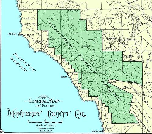
Prior to the creation of the Monterey Forest Reserve in 1906, a number of surveys of the region were conducted. On November 1, 1897, Eleanor Chew noted that "the soldiers engaged on the government survey, who have been encamped in this vicinity, have gone to Soledad."(14) In the years 1900, 1901 and 1902 the United States Geological Survey, in cooperation with Monterey County and the California Water and Forest Association, performed an investigation of the water resources of the Salinas Valley.(15) The survey was performed under the supervision of J. B. Lippincott. In the first year a number of potential reservoir sites were selected, four of which were in the Arroyo Seco watershed. In connection with this project, Lippincott requested William Dudley, professor of botany at Stanford University, to perform a botanical survey of the Arroyo Seco watershed; this was performed in June of 1901.(16)Dudley's report, which must have included a major range extension for the Santa Lucia Fir, was sent to Gifford Pinchot, the Chief of what was then the Division of Forestry of the Department of the Interior.(17) In 1902 a biological survey of the region was performed, but the only information I have about this is from a sentence from one of Eleanor Chew's columns. On June 30th she wrote that: "T. J. Golden and A. C. Behen, Government biologists, passed through here on Sunday."(18)
The most important of the early surveys, in regards to the region's suitability for inclusion into the Forest Reserve system, was performed by U. S. Geological Survey agents Fred C. Plumber and M. G. Gowsell in 1904 and 1905. On July 5, 1904, their activity in the Jamesburg area was noted by Eleanor Chew, who stated that "a party of government surveyors were through this section last week taking observations in the interest of the government timber reserve."(19) The name of Plumber & Gowsell's report, "Forest Conditions in the Monterey Forest Reserve," implies that it had already decided that the region would be included into the Forest Reserve system by the time the report was issued in 1905.
The Creation of the USDA Forest Service.
On February 1, 1905 the supervision of the Bureau of Forestry was transferred from the Department of the Interior to the Department of Agriculture, and in July of that year the agency was renamed the Forest Service. Gifford Pinchot remained the Chief.(20)
Land Withdrawn.
In October of 1905 most of the land of what is now the Monterey Ranger District was withdrawn from settlement by the United States Land Office; this action prompted the following article from the October 26, 1905 edition of the Salinas Weekly Index:
MONTEREY LAND WITHDRAWN.
THREE HUNDRED THOUSAND ACRES THAT ARE NOT SUBJECT TO ENTRY.
Withheld Pending Declaration of Forest Reserve -- List of These Townships -- What They Include.
Some months ago [that month according to my information] the United States Land Office withdrew from entry a large tract of land in this county pending the question of making of it a forest reserve. The purposes of a forest reserve are largely the conservation of the water supply to the streams and the preservation of the climatic conditions. The land withdrawn as given by U. S. Land Commissioner Daugherty for Monterey County is, in round figures, 340,000 acres and lies in the following named townships:
Township 17 South, Range 7 East [i. e., The Pinnacles National
Monument].
Township 18 South, Range 1, 2, 3 and 4 East.
Township 19 South, Range 2, 3 and 4 East.
Township 20 South, Range 2, 3, 4 and 5 East.
Township 21 South, Range 3, 4, 5 and 6 East.
Township 22 South, Range 4, 5 and 6 East.
Township 23 South, Range 5 and 6 East.
There has been considerable inquiry about lands in this section and the list is published for the benefit of those interested. Commissioner Daugherty states that settlers who have got patents to their lands or have acquired rights in connection with their occupancy of the lands will have all their rights respected, but until the matter of declaring these lands a forest reserve is disposed of no new rights to land in these townships can be acquired.
County Surveyor Lou G. Hare, referring to the map, found the following districts included in this withdrawal:
The coast from Palo Colorado Creek to Los Burros (excepting a few sections east of the Sur Rancho), Jamesburg, Cachagua, the head of the Carmel, Tassajara Springs, the head of the Arroyo Seco, Lost Valley, the head of Reliz and Vaquero canyons, the upper Milpitas and the upper reaches of the San Antonio and Nacimiento rivers.
This land withdrawal was also announced in William R. Dudley's "Forestry Notes" column in the January, 1906 edition of the Sierra Club Bulletin (vol. 6, part 1). Dudley, the first professor of botany at Stanford University and an active member of the Sierra Club, stated that "in October of the present year [1905] 343,000 acres were withdrawn from the public domain in the heart of Monterey County, in preparation for the proposed Santa Lucia Forest Reserve. It has been already pretty thoroughly inspected. It concerns the water supply of the Carmel River and the Arroyo Seco and other streams contributory to the Salinas Valley water supply."
1906.
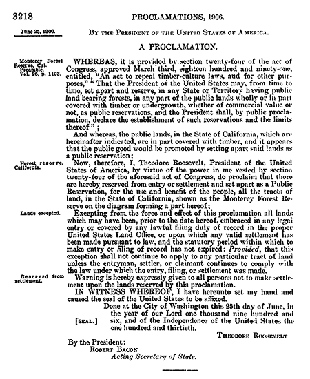
By a proclamation issued by President Theodore Roosevelt, reproduced below, the "Monterey Forest Reserve" was established on June 25, 1906:
The Pinnacles Forest Reserve.
Twenty-three days after signing the proclamation that established the Monterey Forest Reserve (that is, on July 18, 1906), Theodore Roosevelt also signed a proclamation that established the nearby Pinnacles Forest Reserve. The Pinnacles Reserve was placed under the administration of the Monterey Forest Reserve.
The First Car-Campers.
On September 25, 1906, Eleanor Chew reported that "an automobile party of seven, accompanied by a camp wagon, arrived here last night and will go to Miller Canyon today. This is the first auto to attempt the grade above here. H. Dana, of Mountain View, owner of the machine, is in charge."(21)
The Fire of 1906.
Included in the columns of the October 11, 1906 edition of the Salinas Weekly Index was the following item:
SUR NEWS.
Sur. Oct. 8. Mr. Chambers of Monterey has been spending a few days at
the Vantana.
Joe Post made a business trip to Monterey.
Mr. and Mrs. C. Vasquez are in Monterey.
H. Sherman, of Notley Landing, spent a couple of days in Monterey.
A. Cantua went to Monterey Friday to get a half of beef for the men who
were fighting fire.
R. J. Murray returned from Monterey to find that the fire had burned all
his pasture land.
The fire that has been raging in the forests here for the past week is
completely under control, except one branch of it that has swept over
toward Sargent's ranch.
ONCE A WEEK.
Two days later the Salinas Weekly Journal reported that:
The big fire in the coast country, which has been burning for more than a week, is just about extinguished. For a time it threatened to do heavy damage, and many wild reports were circulated regarding it. The fire started in the Palo Colorado and Garrapatas canyons, and burned east and north, covering about 20 square miles and destroying much fencing. B. C. Vandall of the Palo Colorado was the heaviest sufferer, losing his barn and many stands of bees. The Notley company lost a small amount of tan bark. All the residents of the coast turned out to fight the fire, and through their efforts it was confined to an area large in size, but almost inaccessible, and covered principally with brush. Yesterday the fire was reported approaching the Sargent ranch, and R. C. Sargent took out a gang of men to fight it. No fear is felt of damage in that neighborhood.(22)
The fire was far from being controlled, as evidenced by this article from the October 19, 1906 edition of the San Jose Herald:
FOREST FIRE IN THE SUR DISTRICT STILL RAGING.
Men are Exhausted from the Fight with Flames---May Ask Military Aid.
Monterey, Oct. 18.- The fire that has been raging in the Sur district for the last two weeks seems to be doubling its force and is now savagely burning everything in its way above the lime kilns. All women and children have been driven to another locality and men are fighting fire both day and night. Their force has become weakened from exhaustion and loss of sleep and proper food and it may become necessary to call upon Captain Maus, of Monterey Presidio, to send a part of his men down to assist in squelching the fire. The pasture land of Charles Gregg on the Mescal is all gone, and the heavy north wind of the past few days, if it continues, will sweep the fire into Little River. Notley's Landing is in imminent danger.
The fire remained out of control, and on October 25, 1906 the following report was published in the Salinas Weekly Index:
THE FIRE ON THE SUR.
Several Ranches Burned and Culverts on County Road Destroyed.
SUR. Oct. 23.- The fire that has done so much damage in this vicinity is still raging. It has burned all over Pico Blanco. All of A. Dani's pasture has been burned. His house and barn were saved with great difficulty. A. E. Cooper's ranch has been burned over and his feed has all been destroyed. Mrs. M. M. Cooper-Vasquez, E. J. Molera, Joe Schmidt, Sam Ling and Al Clark have also suffered a heavy loss in the same way.
By the heroic efforts of the firemen the Idylwild Hotel was saved. All the culverts and most of the bridges on the county road between Mrs. Cooper-Vasquez's and E. J. Molera's are burned. The Coast stage has to go four miles out of its way, across the Sur flats. The latest report is the fire is below Post's, on the range, still raging fiercely. A gang of men are still fighting it.
Mrs. Cooper-Vasquez will have to get pasture for 500 head of cattle. E. J. Molera is also in the same fix.
A month later the fire was still raging, as evidenced by the following excerpt from a report that appeared in the November 8, 1906 edition of the Salinas Weekly Index:
Mr. Muller describes the devastation caused by the fire that has been raging along the coast for some time as simply terrible. The mountains have been burned bare of trees and vegetation, and the fire is still raging. Dense clouds of smoke were visible in the distance above the hills. The fire is said to have started this side of Palo Colorado. It has traveled over thirty miles. The damage cannot be estimated, for all the feed in the path of the flames has been destroyed and all the stock will have to be driven elsewhere for the winter.(23)
Additional information about this fire comes from John Woolfenden, who, in an article about the damage caused by the Marble-Cone fire of 1977, stated that:
Newspapers of October, 1906 - the Los Angeles Herald, San Jose Herald and Fresno Republican -- reported the largest forest fire in Monterey County in 20 years, 25 miles long and 10 miles wide. It was said have started in Wildcat Canyon, from an untended campfire, and after raging for eight days, to have "reached the Santa Lucia Government Reservation, known as The Pines, spreading toward Tassajara eastward and Arroyo Seco southward." On the coast it extended between Garrapata and Mill Creeks. In all, it was said to have covered more than 150,000 acres.(24)
As the newspaper collection of the Bancroft Library does not include the Los Angeles Herald or the Fresno Republican from that year, I have not seen two of the articles mentioned by Woolfenden. Based on the information I have, the fire may not have been so large, for, as will be seen in the reports about the subsequent flood, at that time "Bixby Creek" was known as "Mill Creek." Thus it is possible that the Mill Creek referred to here is not the same as the Mill Creek located about 36 miles to the south. Also, the fire was not mentioned in the literature pertaining to Jamesburg and Tassajara dating to October and November of 1906. There was, however, a surprising entry in one of Eleanor Chews' columns, dated Oct. 29, which stated that "we had a nice rain here Saturday night and Sunday amounting to about one inch."(25)
A Forest Service Agent Arrives.
In November of 1906 an agent from the "Bureau of Forestry" paid a visit to Monterey County to perform preliminary work related to the establishment of the Monterey Forest Reserve. Such work included making estimates regarding various costs, such as figures on the erection of telephone lines to various ranger stations. Although "an effort was made to have the office of Supervisor of Forestry located at Monterey, the agent favored Salinas."(26) In December of 1906 N. O. Torstenson, a ranger at the San Bernardino Forest Reserve, was appointed of Supervisor of the Monterey Forest Reserve.(27)
1907.
The following article was featured in the January 7, 1907 edition of the Salinas Daily Index:
SUPERVISOR OF FORESTRY.
ARRIVES AND ESTABLISHES OFFICE IN McDOUGALL BUILDING.
Salinas to be Headquarters for Entire System of Santa Lucia Reservation.
N. O. Torstenson, United States Supervisor of Forestry for the reservation recently set aside in the Santa Lucia range, has arrived and established permanent headquarters in Salinas with [an] office in the McDougall building.
The reservation over which Mr. Torstenson will have charge embraces 337,000 acres, and he will have supervision over forest rangers in various portions of this large scope of country to prevent the spread of fires and guard against the illegal stripping of the land of timber. There will be a number of these stations which will be connected by telephone with the supervisor's office in Salinas.
A force of men is now engaged in cutting trails at various points in the mountains to enable the rangers to ride over the country and report conditions.
It is Supervisor Torstenson's intention to have the whole system in good working order as soon as the rainy season is over.
Mr. Torstenson comes here from San Bernardino, where he has been engaged in government forestry work for the past seven years.
A Tree Plantation.
Based on the early records of the Monterey Forest Reserve, one of the first projects undertaken during Torstenson's administration, on February 11, 1907, was the planting of Ponderosa Pines, Big Cone Douglas Firs and Deodor Cedars in the vicinity of "The Lakes" in the Arroyo Seco area. The trees were planted on 30 acres of land, at a density of about 200 trees per acre.(28) In November of that year it was reported that "last year about 5,000 trees were set in the forest. The conditions were not altogether favorable, both on account of the inexperience of those who did the work and the imperfect knowledge of the surroundings."(29) Although the experiment was considered to be a failure, some of the trees survived. According to Jon Libby, "I have seen BC Firs on two ridges, one south of Santa Lucia Creek and one north. On the north there are a good number of trees and new seedlings. I've also seen Deodars on the trail from Cawatre to Arroyo Seco."(30)
"Forest Reserves" renamed "National Forests."
By and Act of Congress on March 4, 1907, the "Forest Reserves" were renamed "National Forests." The change was made in order to emphasize that the resources were open for the "conservative use compatible with the preservation and perpetuation of these resources."(31) Prior to the passage of the Organic Act of 1897, the resources of these lands were "reserved."
The Floods of 1907.
The winter of 1906-1907 was an exceptionally wet one in Monterey County. Salinas, for example, received 24.19 inches of rain, about 200 percent of normal. Due to the loss of groundcover in a large area of the Santa Lucia Mountains caused by the fire of 1906, the rains could not have come at a less opportune time. The first major storm arrived within a few weeks after the smoke had cleared, for on December 11th Eleanor Chew reported that:
The heaviest windstorm that has visited this section in many years was felt here Sunday and Monday morning. Timber was blown down everywhere, a great many trees fell across the road and the mail carrier had to chop his way through today. However the wind brought the much needed rain and all day a warm rain has been falling.(32)
By the end of December Jamesburg had had already received 10 inches of rain.(33) Frequent rains, accompanied by snow at higher elevations, were the norm in January of 1907, as evidenced by the following excerpts from some of Eleanor Chew's Jamesburg news columns:
January 8. We are having one of the heaviest rains we have had for 15 years. It began Friday afternoon and still continues. Sunday it snowed all afternoon and last night it began to rain at 6 p.m., and it rained heavy all night, amounting to 2¾ inches. The roads are badly washed out and the Cachagua creek was so high the mail carrier could not cross with his wagon...(34)
January 14. Its rain, rain, then snow and then some more rain: it both snows and rains every day, and while here the snow has not more than covered the ground and does not lay long, on the higher altitudes it is accumulating and is now about five feet on the summit [of Chews Ridge]. There has been over twenty inches of rain for the season so far and its still raining. The roads in every direction are badly washed, and bridges and culverts are gone...(35)
January 21. At last the storm has broken and three days of lovely sunshine have been given us. This morning a regular "Chinook" wind was blowing which ought to eat into the snow. The snowfall on the highest mountains is probably the heaviest ever known. It is impossible to get to the summit, but from the rain which has fallen here, over thirteen inches, there must be at least nine feet of snow on a level where none has melted, and much deeper in drifts. There is three and a half feet of snow at Frank Bruce's place half way up the mountain, and he has been compelled to bring his hogs down to the lower lands... The rainfall here Wednesday night was three inches, making a total of thirteen inches for January and twenty-four for the season...(36)
The January storms caused a good deal of damage in the Salinas Valley, and at one point the Salinas River rose to the 19 feet 6 inch level; this caused the flooding of extensive areas of farmland.(37) In the later part of March, 1907, there was another large storm, but this one seems to have had its most detrimental consequences in the mountains, especially along the coast. According to an article by Eleanor Chew, dated March 31, 1907, at Jamesburg:
We are having all kinds of weather. It has rained so much that the ground is thoroughly soaked and the creeks are very high. We have had more than our share of rain this winter. The roads are washed out very badly. All bridges between here and Laurelles are washed out. We have had 36 inches of rain for the season. Tuesday and Wednesday mornings the ground was covered with snow...(38)
While this storm added to the problems in the Jamesburg area, it had a much more devastating consequence along the coast, as evidenced by the following article that appeared in the March 30, 1907 edition of the Salinas Weekly Journal:
TERRIFIC STORM IN COAST SECTION.
A special to Tuesday's Monterey Cypress from Sur, dated Sunday, March 24, has the following account of an unprecedented storm on the coast section below Monterey: A terrific storm had raged in the coast section for a week. All the streams are running over their banks, bridges are gone and roads are impassible. News was received this morning that Mill [Bixby] creek rose twenty feet yesterday afternoon, washing out all the bridges.
The flood carried off the lime kiln barns, smashing them into the house occupied by the family of J. C. Silva and Thomas Fussel, totally wrecking the house. All of Mrs. J. C. Silva's furniture is ruined.
The house of Al Cushing was saved by a log turning the flood, but all of his outhouses were swept down stream.
The Sur post office was washed up against the hillside.
Two feet of water now stands in H. M. Hoge's parlor.
Piles of driftwood are now wedged up against the Palo Colorado schoolhouse.
The stream has now gone down some, and unless the rain continues, most of the damage is over.
Last Sunday night it began raining and has continued to do so up to this time. The coast mail could not reach the Post post office last Monday because of the swollen rivers, and could not get back to the Sur post office until Wednesday, where it has been until today, when the stage driver will try to get to Monterey by horseback.
There are no roads whatever, hardly a trail left, and in some places not even that. Most of the bridges are washed out and all of them are more or less damaged.
At Mal Paso, where the road was built up with rocks, the road slid out and at Double Gulch one bridge is gone and the place is all slides.
At Garrapatas the bridge still stands but the water has cut deep channels on each side so the creek has to be forded to cross at all.
It is reported that a large mass of rock and earth slid out of the Point Sur Light House Rock, and all the women have moved up to the Swiss Canyon Dairy to stay until the storm is over.
The lime kilns can be reached only by foot. All the bridges are gone.
Between the Hotel Idlewild and Mrs. Cooper-Vasquez' for a distance of
about one hundred feet the road has slid into the canyon.
R. M. Smith with a gang of men is out working on the roads, but it will be weeks before they will be fit for travel.
Such a storm as this has never been witnessed by anyone in the coast section before.
Civil Service Exams.
In the mean time, and for reasons unknown, Supervisor Torstenson was rather late in hiring a formal staff for the Monterey National Forest. It was not until late June of 1907 that it was announced that Torstenson would be holding civil service examinations in the later part of July. An excerpt from this report stated the following:
The Forestry Service is in need of good men. The pay and opportunities for promotion are good. The pay is $75 a month and, after a successful probationary service of six months, the position is a life tenure. But the Forestry Service wants good men- men who know how and are willing to do the work required, not those who are looking for "snaps" with salaries attached.(39)
The applicants were required to apply to the Civil Service commission in Washington for application forms, which they sent back to Washington in order to get a card entitling them to enter the examination. On July 23 the written examination was held. The six hour session was without intermission, and neither the "examiner or the examined" were allowed to leave the room at any time. "Talking back" or "to the side" was strictly forbidden. On the 24th the field test was conducted, at which the applicants had to demonstrate their skills in horsemanship, packing, compass work, measuring distances, and so on.(40) Those who passed the test included Carl L. Abbott, Steven J. Foster, Sylvester Gilkey, William E. Moore and Francis P. Porcher.(41)
Santa Lucia Peak Becomes Junipero Serra Peak.
The following article was published in the August 5, 1907 edition of the Salinas Daily Index:
A NEW NAME FOR MOUNTAIN PEAK
SAN[TA] LUCIA'S HIGHEST POINT IS NOW JUNIPERO SERRA.
Native Daughters Succeed in Getting U. S. Geographical Board to Honor
Good Padre.
C. S. Sloane, secretary of the United States Geographical Board, has officially informed Mrs. Lily O. Reichling-Dyer, founder of the order of Native Daughters of the Golden West, that her efforts and those of Cora Bonestel Sifford and Harriet Stoddard Lee, to have the highest peak in the Santa Lucia range of the mountains in Monterey county named Junipero Serra have been successful, and that the name is now given to the peak formerly known as Santa Lucia.
The movement to have this change of name began more than a year ago, at the session of the Grand Parlor in Salinas. The idea was endorsed by the President of the United States, the United States Geological Survey, the National Geographical Society of California, the Geographical Society of the Pacific, the California Club and the Sierra Club. In a letter to Mrs. Dyer, Scientist George Davidson wrote:
"In that remarkable range, overhanging the Pacific for fifty miles, are peak which are landfalls for our navigators and they were familiar to the early fathers. The name of Junipero Serra upon one of these coast peaks that barred the expedition of 1769 and 1770 will be a living designation, appealed to every day by the mariner and traveler."
Henry Gannet, chairman of the U. S. Board on Geographic Names, wrote from Washington:
"The Santa Lucia peak is the highest summit in the Santa Lucia range, forty miles southeast of Monterey, in the midst of the scenes of the Father's labors. It is probably the highest peak in the coast ranges south of San Francisco and has an altitude of very nearly 6,000 feet."
Telephone Line.
As stated earlier, the creation of a telephone system in the Monterey National Forest was one of first objectives of the Forest Service. According to a report in the September 23, 1907 edition of the Salinas Daily Index:
Supervisor Torstenson of the Monterey national forest has been authorized and instructed to call for sealed proposals to furnish the materials for the erection of a government telephone line from Soledad into the national forest to a point on the Arroyo Seco twenty-seven miles from Soledad, where a forest ranger's house is soon to be constructed. Mr. Torstenson has obtained the rights of way needed over private property and he anticipates no trouble in getting the right along the county road from the Board of Supervisors. It is probable that this line will be extended to H. B. Leigh's place, four miles farther(42) [i.e., at "The Adobe" or "Leigh's Adobe," which was located near the junction of the Marble Peak and Horse Pasture trails].
A week later the Index also ran an Associated Press release that stated the following:
Washington, Sept. 28. Supervisor N. O. Torstenson of the Monterey national forest, California, has been authorized to expend $1856 for permanent improvement work on that forest. This appropriation is for the construction of twenty-seven miles of telephone lines, which will extend from Soledad to rangers' headquarters on Santa Lucia creek. Ranchers on the line will cooperate in the construction and will receive in return the free use of this line. One of the larger ranchers will extend the line four miles farther and will give the forest service free use of his line for the right to connect with the forest service line. There will also be constructed a new cabin for the ranger at Sata Lucia station at a cost of $400...(43)
The Santa Lucia Ranger Station, mentioned above, was constructed along Santa Lucia Creek at the site of the former Camp Cawatre Girl Scout Camp.
Trout.
Although Supervisor Torstenson was far from being the first to introduce of non-native trout into the streams of the Santa Lucia Mountains, one of his early projects as the Supervisor of the Monterey National Forest was to have the streams stocked. According to a report in the June 7, 1907 edition of the Salinas Index "Mr. Torstenson is arranging to stock the streams of the Monterey reserve with trout, and has made a requisition on the State Fish Commission for young trout which he expects to receive in July. He hopes to get between one and two million of them." Instead of one or two million spawn, Torstenson had to settle for the 80,000 that arrived in early October of that year. The cans of spawn, which were shipped by train from a hatchery in Shasta County, were received at Soledad, and then hauled as far as possible by wagon. From there they were packed on horses to the headwaters of the Arroyo Seco, Carmel and Big Sur Rivers for release.(44)
Fire Stations.
Yet another project undertaken by Torstenson during the first year of his administration of the Monterey National Forest was the construction of five fire stations at different points in the forest. These structures, which strongly resembled outhouses, were used to store fire-fighting equipment. They were kept locked, but all the rangers and guards had keys.(45)
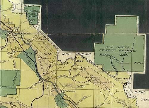
The San Benito National Forest.
On October 26, 1907, by a proclamation by Theodore Roosevelt, the San Benito National Forest was created. This region was comprised of approximately 140,000 acres, and included San Benito Mountain, the highest point in the Diablo Range. Like the Pinnacles forest, the San Benito forest was also placed under the administration of the Monterey National Forest.(46)
Two Tree Plantations.
On November 14, 1907, it was reported that: "the reforestation of the barren spaces in the Monterey national forest is just now receiving special attention. Supervisor Torstenson has just shipped to the watershed of the Arroyo Seco 20,000 young pine trees from the government nursery in Santa Barbara. These he will plant on the northern and eastern slopes along trails, where their growth can be watched and protected."(47) The trees were Jeffrey Pines, which were planted to the north and northeast of Cone Peak (in sections 34 and 35, T21S R4E) and on the eastern slope of the Coast Ridge between Anthony and Los Burros creeks (in sections 19 and 20, T23S R6E). These plantations were later reported to be failures.(48)
The First Annual Report.
On December 19, 1907 the following article was published in the Salinas Daily Index:
FOREST SERVICE IS APPRECIATED.
THE FIRST YEAR IN WHICH THERE WERE NO FIRES HERE.
Supervisor Torstenson Sends Gratifying Report to the Forester at
Washington on Season's Work.
United States Forest Supervisor Torstenson has made his annual report on fires in the Monterey national forest for the past season. The work done by the forest service is thoroughly appreciated by the people of Monterey County, especially by those who have stock or lumber interest in that section. In other years its has been almost invariable experience that fires would occur on the mountains to the south during the dry season. Columns of smoke would rise by day and settle over the mountains and when finally the fires would be burned out large areas would be devastated.
This season it has been different. Mr. Torstenson reports that six camp fires were discovered by forest guards and put out before much damage was done. Two of these occurred when the United States troops were out on a practice march on Aug. 18 and 20. In one of these 150 acres were burned and the other 320 acres. The troops materially assisted in putting these out and proved good fire-fighters.
On Sept. 3 a camp fire was maliciously set. It burned only thirty acres when it was extinguished. It was impossible to get legal evidence to convict and no prosecution was undertaken. The other camp fires of less consequence.
Forest Guard Porcher fought a small fire on Oct. 2nd, which burned only a few acres, and Forest Guard Gilkey subdued another on June 17th with the assistance of settlers that burned about 330 acres, only forty of which were in the national forest. This fire is supposed to have been caused by matches ignited by the sun's rays in a workman's coat.
Mr. Torstenson reports very cheerful cooperation of the residents in and near the national forest with the forest guards in all their efforts to enforce the wise regulations of the forest service.
Perhaps one of these fires was the one that Eleanor Chew, on December 2nd, reported as follows: "brush fires have made the air heavy with smoke for the past few days."(49)
1908.
The year 1908 was a very eventful one in the history of the Monterey National Forest.
The Marble Peak Trail.
On January 3rd it was announced that Supervisor Torstenson had "sent ten men into the national forest at Arroyo Seco to work on trails that are to be opened from that point to the coast and then along the forest southerly. He will send several more in a few days and expects to have twenty at work under the direction of Forest Ranger Alverson for months." There is no doubt that the trail being cleared was what is now known as the Marble Peak Trail. The same article also stated that the telephone line from Soledad to Arroyo Seco was completed, except for the installation of the "instruments."(50)
As for the Marble Peak Trail, its general route was in existence long before the establishment of the Monterey National Forest, and in prehistoric times it certainly served as the main route between the coastal Esselen district of Ekheahan and those of the interior. Prior to the establishment of the Monterey National Forest the route was known as "Leigh's Mountain Trail," for it linked three properties owned by J. W. Leigh. These properties were located in Lost Valley, Indian Valley and along the lower stretch of Tassajara Creek. After the establishment of the Monterey National Forest the route was known as the "Government Trail," perhaps due to the work mentioned above. Later on it was called the "Arroyo Seco Trail," and up until the early 1950s it was commonly known as the "Willow Creek Trail." Its current name appears to have come into existence after it was depicted as such on USGS 7.5 minute topographical maps that were produced in the mid 1950s.
The Forest is Enlarged.
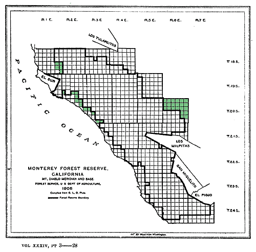
Later in the month of January, 1908, Supervisor Torstenson received notice from the Forest Service headquarters in Washington that on the 9th day of that month, by a proclamation by President Theodore Roosevelt, about 25,000 acres were added to the Monterey National Forest. The lands were comprised of 39 sections, 22 in the lower Reliz and Vaqueros Canyons, 12 along the coast from Big Sur to Buck Creek, and five in the Pico Blanco area.(51)
The Pinnacles National Monument.
It was less than a week after the additions were made to the Monterey National Forest, that is, on January 16, 1808, that President Roosevelt signed a proclamation that set aside a portion of the Pinnacles Forest as a national monument. This act provided permanent protection for the area of the Pinnacles Forest in which "the jagged peaks known as The Pinnacles" were located. The movement to have the peaks protected for their scientific value began in 1904; it was lead by "Hon. J. C. Needham and other influential Californians." The area remained, however, under the jurisdiction of the Monterey National Forest.(52)
Projects are Planned.
According to an article titled "Our National Forest," which appeared in the February 10, 1908 edition of the Salinas Daily Index, Forest Service engineer Joseph Y. Work was:
...in the Monterey national forest making estimates on the cost of extending the telephone line from Arroyo Seco to the coast and opening a trail from Arroyo Seco to the Sur country [it would be named the Pine Ridge Trail]. He will also select locations for ranger's stations in the forest. [Chief] Forester Pinchot is supporting and pushing improvements in all national forests with vigor, and the people of Monterey County are greatly pleased to know that their national forest is getting its fare share of attention. Forest Supervisor Torstenson will go to San Francisco tomorrow morning on telegraph orders to meet officials at the office of the Forest Inspector there.
Forestry Convention.
In late February of 1908 a forestry convention was held at Salinas. The meeting was directed by Forest Inspectors William C. Hodge, J. H. Hatton and George W. Peavy, of San Francisco, N. O. Torstenson, supervisor of the Monterey, Pinnacles and San Benito National Forests, and E. S. Mainwaring, the supervisor of the San Luis Obispo National Forest. The audience was comprised of all of the rangers and guards of these forests. The session included "a thorough investigation and discussion of mineralogy, zoology, bacteriology, planting, fire-fighting, etc., as far as these things enter into the duties of the rangers, guards and supervisors."(53)
Back on the Marble Peak Trail.
In the mean time Ranger Alverson's trail crew had grown to 17 men. According to a report in the March 31 edition of the Salinas Daily Index the men were working from a base camp that was:
Pitched near a spring of excellent water. Its line of tents faces a plaza, on which at night there is a fine campfire. There is no intoxicating liquor permitted, and no gambling allowed and no disreputable characters are admitted. There are other rules that tend to make the camp an agreeable place to live in. It is kept as neat as a regular army post. Everybody gets a square deal and good grub.(54)
It is easy to imagine such a camp at a number of locations along the Marble Peak Trail, such as at Willow Springs Camp, in Strawberry Valley, or on the banks of Camp Creek. According to Jeff Norman, Forest Service tradition has it that Camp Creek was "so named because there had been a trail camp here during the construction of the Marble Peak Trail."(55) Shovel Handle Creek was also named at this time.
The article quoted immediately above also stated that:
The Forest Service is only beginning the development of the resources of the Monterey Forest. Every year there will be more improvements and more men will be needed to care for the public's interest there. Soon there will be a civil service examination here of applicants for positions as forest rangers. As the Forest Service becomes better known more young men are anxious to enter it. Mr. Torstenson has received calls for many application blanks. The examination will be held on April 23 and 24.(56)
A few days before the examination was held, Torstenson received a telegram from Forest Service Headquarters stating that he was to attend a three-month course on general forestry matters. On May 1, 1908 Supervisor Torstenson departed for Washington D. C., and during his absence deputy ranger Francis Porcher assumed the position of acting supervisor.(57)
Ranger Districts.
In late May of 1908 it was announced that the rangers and guards would be stationed at their respective districts by June 1st, when their summer work of fire patrolling and overseeing stock grazing would begin. The rangers were as follows:
District No. 1 (the Chews Ridge, Jamesburg and Tassajara regions), John
J. Lindt.
District No. 2 (the northern half of the Big Sur Coast), Sylvester
Gilkey.
District No. 3 (the Arroyo Seco area), Carl Abbott.
District No. 4 (the San Antonio and Nacimiento watersheds), Walter
Fulton.
District No. 5 (the southern half of the Big Sur Coast), William Moore.
The Pinnacles, J. E. Alverson.
San Benito Forest, William McGuire and William A. Donahue.(58)
Gilkey, Abbott, Fulton, Moore and Alverson were Forest Rangers, while Lindt, McGuire and Donahue were Forest Guards;(59) Lindt may have served as a fire scout on Chews Ridge.
Two More Ranger Stations.
On June 30, 1908, it was announced that $1.500 had been authorized for the construction of "two Forest Ranger's headquarters," one in the Monterey Forest and the other in the San Benito Forest. The article stated that the "cabins will be built by the Ranger force and will be 20 by 24 feet. Each station will have a barn 14x20 feet and a pasture fenced off for their cows and saddle stock." Although it was stated that the station in the Monterey Forest was to be "known as the Jamesburg" Station, no other information was provided.(60) At first I assumed that this was the station on the summit of Chews Ridge, but in the following January, Eleanor Chew reported that "there is three feet of snow at the Forest Guards camp. It is impossible to get farther up the mountain, but it is estimated that there is at least seven or eight feet on the summit."(61)
The Consolidation of the Monterey, Pinnacles and San Benito Forests.
Although the San Benito and Pinnacles forests had been placed under the administration of the Monterey National Forest from the start, it was not until July 2, 1908, by an executive order by President William Taft, that the three forests were officially consolidated under the name Monterey National Forest. The same order consolidated many other national forests in the western United States.
The Fire of July, 1908.
In July of 1908 a fire broke out in the mountains adjacent to Rancho Las Milpitas, which Game Warden Shook, who was on the scene, reported to be "fierce." He also thought that no "force that could be sent out to fight it could get it under control until it had burnt its way to the ocean." In response, Acting Supervisor Porcher departed for Jolon, from where he "intended to ride in to the trouble from that point" on horseback.(62) It was also reported that:
Thus far only brush and feed have been destroyed, with some few dwellings and fences, but should it go to the limit considerable pine timber will be destroyed. This promises to be the most important fire since the Monterey national forest was established. The season has been dry for a long time and everything is like tinder.(63)
This fire appears to have been quickly controlled, for I did not find any subsequent newspaper reports about it.
Attention Given to the San Benito Division.
After his return from Washington D. C. in August of 1908, Supervisor Torstenson performed a ten-day inspection of the San Benito division of the forest. It was reported that:
He is finding considerable sale for timber and wood for fuel at the New Idria mines. For some years crude oil has been used for fuel at the mines, but now they are going back to wood, and the fallen timber in the forest reserve is made use of to the advantage of the mines as well as of the forest service. Old trees and brush that have for years encumbered the ground until the sap part has all rotted away are sold to the mines for 75 cents a cord as the stuff lies on the ground. The mine management has this gathered up and corded. Every piece is saved if its not more than two inches in diameter or a foot long. This scraping up of the debris of the neglected forest leaves the ground much improved for grazing. The forest service gets something for the wood and mines get good fuel for less that it costs to get the same steam out of crude oil. This wood costs the mines $5 or $6 a cord, delivered, as much of it has to hauled over steep ridges. The outlook for getting that forest pretty well cleaned up is very good.(64).
The Fires of August and September, 1908.
The following five articles were published in the Salinas Daily Index between August 26 and September 15, 1908:
August 26.
FIRE THREATENS NATIONAL FOREST.
SUPERVISOR TORSTENSON GOES TO THE CACHAGUA EXPECTING A HARD FIGHT.
Reported to be Ten Miles Wide and Blown Up the Mountains By a Strong
Wind.
A forest fire of great extent is reported from the Cachagua. Forest Supervisor Torstenson yesterday afternoon saw smoke rising in big volumes over the Monterey national forest and he called the telephone into requisition from every direction to learn whence it started, its extent and what available resources there were to engage in fighting it. He received advice from the forest rangers who were accessible to telephone and they were all advised of the situation and instructed to proceed to the scene with all dispatch, prepared to fight the fire.
The ranger away in the Los Burros district [William Moore] saw the smoke and telephoned for instructions, which were that he should get to the fire as soon as possible. All this forenoon Mr. Torstenson was busy gathering information and engaging assistants in the work before him and this afternoon he set out by team for the Cachagua to make a fight to save the forest.
Mr. Torstenson says he can get 25 or 30 men on the reserve or near it, and he is hopeful to get the fire stopped before it gets far into the forest. The reports that reached him were to the effect that the fire extended along a frontage of ten miles and was being carried rapidly up the mountains, and he feared that it would reach the national forest, although it was not then reported to be in the forest. It is supposed to have started from the Monterey side.
On the following day (August 27) Eleanor Chew reported the following:
The forest fire which started on the Sargent ranch has been coming this way and now is so near that the fire guard, Carl Abbott, has all out who could leave their homes to keep the fire from crossing the Carmel river. Should the fire cross the river everything in this burg will be burned out.(65)
August 31.
FIRES RAGING IN NATIONAL FOREST.
RANGERS ARE RALLYING FIGHTERS IN FIVE DIFFERENT DISTRICTS AT ONCE.
Supervisor Torstenson Returned from Cachagua on Saturday to Assume
Direction of the Campaign.
Monterey national forest is threatened with forest fires in five different places at the same time, and Forest Supervisor Torstenson's resources are taxed to the limit in trying to save the forest from being swept from one end to the other. Mr. Torstenson returned from the Cachagua district Saturday night, leaving the outlook there very satisfactory. The fire seems to have spread from San Francisquito rancho, but when Mr. Torstenson left it appeared to be under control. Where there appeared little columns of smoke there was help directed to put it out. These were smoldering piles where the fire had passed.
But today the situation is reported to be alarming. Word came in that fire had broken out on the Arroyo Seco and Forest Ranger Porcher went down on train 24 to take charge and direct the fight there.
Rangers Alverson and Fulton were reported as having gone from Jolon over toward the coast to put out fires raging between Cone peak and the ocean. Ranger Moore was busy with a fire in the Los Burros district. Ranger Abbott was fighting fire on the Cachagua and Ranger Gilkey was farther west and north in the vicinity of Ball's place. Supervisor Torstenson remains at his office to receive reports and give general direction to the fighters in these widely separated places.
Fred P. Feliz had a telephone message from Monterey this afternoon saying that the fire had swept his ranch and taken all his buildings, fences and feed. He did not think his loss would be very great, but Mr. Torstenson discounts this report, as on Saturday afternoon when he left that section the fire had been put out after burning up one shed with a wagon and cart and a large lot of feed and fencing.
The smoke is thick in that direction today. Much of this is said to have come from fires in the redwoods above Santa Cruz. The temperature is believed to have been raised considerably by these fires, and as there are no fogs and everything is getting drier, the prospect is not promising.
There is a feeling among the mountaineers that these fires may not all be accidental.
Later - At 3:30 this afternoon Mr. Torstenson had a message from Mr. Porcher at Soledad stating that there is no fire on the Arroyo Seco.
September 1. FIRE SITUATION GROWING BETTER.
SUPERVISOR TORSTENSON FINDS NO SMOKE IN THE CACHAGUA DISTRICT.
Ranger Porcher Starts from Arroyo Seco Across to Cone Peak.
Forest Supervisor Torstenson reports the fire situation in the northern part of the Monterey national forest as much more favorable today. He has heard of no new outbreaks since he left the Cachagua on Saturday and has not been able to see any disquieting columns of smoke rising from the mountains in that direction.
Mr. Torstenson this afternoon had a telephone message from Forest Ranger Porcher at Ranger Alverson's camp on the Arroyo Seco [the Santa Lucia station], stating that he was about to start then for the scene of the fire in the Cone peak district, where the fire is said to be burning over brushy areas, as it burns up and soon dies down again, showing that it is not in the tall timber.
September 4.
MORE FIRES BREAK OUT ON THE CARMEL.
FOREST RANGERS LEAVE SECTION SAFE ONLY TO BE RECALLED TODAY.
Forest Supervisor Torstenson in Great Perplexity to Account for the
Trouble in That Section.
The fire situation on the Carmel seems to be uncertain, precarious and altogether unaccountable. Yesterday afternoon Forest Rangers Abbott and Gilkey, who have been fighting fires there for a week, assisted from time to time as the exigencies of the case required by the settlers and residents, left, having extinguished the last smoldering faggot, and went over to the Arroyo Seco. They reported to Forest Supervisor Torstenson that everything was in good condition.
This morning Supervisor Torstenson was perplexed and annoyed to see volumes of smoke rising from that section again. He got into communication with Rangers Gilkey and Abbott and instructed them to return the Carmel and extinguish the fires that have broken out anew. Mr. Torstenson says the smoke today indicates that it comes from grass, and not from timber, but it is going to keep the forest rangers busy to prevent grass fires from extending into the timber and causing great loss to settlers well as to the government. The way the fires have spring up in that section this year, after they have been put out by the forest rangers and settlers, is particularly exasperating, and its seems unsafe to withdraw the rangers from that section to have them assist in other places where there may be fires.
Forest Supervisor Torstenson had a telephone message from Jolon at 2 o'clock this afternoon giving him the welcome news that the fires in the national forest in that section and over toward the coast are wholly under control.
September 15.
FOUR DAYS' FIGHT WITH FOREST FIRES.
SUPERVISOR TORSTENSON RETURNS FROM A VERY STRENUOUS CAMPAIGN.
Thousands of Acres Along the Northern Boundary of Monterey National
Forest Swept by Fire.
Forest Supervisor Torstenson and Forest Ranger Porcher have returned from a strenuous campaign against fires along the northern border of the Monterey national forest and in the country contiguous to the forest, west of the Carmel river. They were there four days and nights and only ceased from their labors on Sunday, when they found no more fires to fight.
This was the hardest battle they have had this year against 'the fire fiend.' This very undesirable personage- if there is such a being, so dear to the cub reporter's vocabulary- has been appearing most unexpectedly in that part of the mountains this year, after the forest rangers and the ever vigilant and valiant settlers have put out every visible sign of the fire. Sometimes it looked to the fire-fighters as though some malicious purpose was behind the oft appearing fires, but Mr. Torstenson does not attribute their frequent breaking out to malice, but rather to smoldering embers fanned to flame by a favoring breeze.
Mr. Torstenson says, besides himself and Porcher, Forest Rangers Abbott and Gilkey were there, reinforced by residents to the number of ten or twelve during the hottest of the fight.
The fire ran over exceedingly rough country. It crept across ridges through canyons in the bottom of which the gathered debris of leaves, twigs and fallen timber made combustible fuel for the flame, which would break out and sweep up both sides. Thousands of acres were burned over, but the fire was kept out of the timber.
The forest service men were very short on provisions and water and long on smoke, heat and ashes. Small pieces of bread, coffee and sardines were breakfast, dinner and supper during the last days, and when they got out some of them had shirts on and some had not, but whatever clothing they did wear was in rags, while none of them looked like white men.
"The Pinnacles and Their Future."
By the fall of 1908 controversies over the future of the Pinnacles Forest were brewing. As previously mentioned, in January of that year part of forest was proclaimed a national monument. According to a report in the November 3rd, 1908 edition of the Salinas Daily Index:
The scientists, naturalists and students of nature want more land taken in to protect the beauties and attractions found there, and especially to protect the flora of that spot. It is said that there are varieties of flowers at The Pinnacles that are found no where else. The botanists and geologists want all these things and plants preserved as they are now. Dr. Jordan and Professor Dudley of Stanford are especially insistent on this.(66)
Local residents, however, were lobbying to keep the area in the national forest system, while the Forest Service was somewhere in the middle, but leaning toward the views of the scientific community. According to same report the forest inspectors:
...have reported that there is not enough timber and enough grazing land available in that section that, if reserved [in the U. S. Forest system], would make the national forest, if it were put into a forest, self sustaining. The inspectors are practical men.(67)
District Headquarters Established.
It was also in the month of November, 1908, that Supervisor Torstenson received an important letter from Chief Forester Gifford Pinchot. The letter stated that beginning on December 1, 1908, the national forests of California would be administered by District Forester F. E. Olmstead from an office that was to be established in San Francisco.(68)
A Eucalyptus Plantation at Pfeiffer Beach.
On December 27, 1908, the Forest Service planted 700 eucalyptus trees on three acres in section 34 of T19S R1E. This must have been a typo, for section 34 is located in the Pacific Ocean. They were probably planted in section 35, which would place them in the immediate vicinity of Pfeiffer Beach. In 1914 this plantation was listed as: "failure, drought."(69)
"Mr. Torstenson's Growing Museum."
An article, as titled above, appeared in the December 30, 1908 edition of the Salinas Daily Index. The text is as follows:
Forest Supervisor Torstenson is gathering up relics of bygone days in California, when there was not so much civilization i
Among his recent acquisitions is a heavy short sword, double-edged and
heavy, with a brass handle loaded with lead. This is said to have been
used by one of the Great Pathfinder's [Fremont?] artillery-men when he
forced his way over disputed territory in this county. It was picked up
on the Alisal years and years ago and taken to the Sur country by a
member of the De la Torre family, who put it to good use in cutting
brush out of trails along the mountains. It is sharp and bright. Forest
Ranger Gilkey saw it and coveted it, and was successful in negotiating
for its possession. Then Mr. Torstenson saw it, and wanted it for his
growing museum, and negotiated for it with Ranger Gilkey. It occupies a
prominent place in the museum.
Another relic is the main part of a Hicks gun, one of the earliest forms of breechloaders made. This gun broke two or three inches in front of the hammer, and it used percussion caps. It had a sliding ring along the left side of the barrel to hold a strap to sling it over one's shoulder. It was found in the Sur country by men digging postholes and Ranger Gilkey got it for Mr. Torstenson. It may have been left there by pirates in piratical days, now happily gone forever. It is nearly eaten up with rust.
Ranger Gilkey has saddlebags which it is said were once used by the notorious bandit Tiburcio Vasquez, but he keeps these.
Many other curios of great historical interest are in Supervisor Torstenson's collection.
The same edition of the Index included the following report about the construction of the Paso del Rio station:
A RANGER'S STATION.
Forest Supervisor Torstenson is preparing to build an up-to-date ranger's station in the San Benito division of the Monterey National Forest, as that reserve is officially known. This will be a formidable undertaking. The lumber is hauled in from King City, a distance of thirty-seven miles, much of the way up and down hill. The portage makes a large proportion of the cost.
The house will contain five rooms, and there will be a barn and fences and a water supply will be developed in the mountains. The cost of the materials will be something more than usual, and the work will be done by Supervisor Torstenson and the forest rangers.
The station will be erected southeast of Hernandez about six miles.
1909.
The Floods of January and February, 1909.
The months of January and February, 1909, were unusually wet ones in Monterey County, and over eleven and a half inches of rain fell at Salinas during that period. Rainfall totals, as always, were much greater in the Santa Lucia Mountains, and the runoff caused the Salinas River to once again cause extensive damage in the Salinas Valley.(70) The following reports describe how things unfolded at Jamesburg:
January 18. The last storm amounted to 4.24 inches of rain, as measured by the standard rain gauge recently set up at the post office. Ernest Waterman is out from Tassajara Springs. He reports heavy rains and very high water at the Springs. He says he did not have any rain gauge to measure the rain, but the iron wheelbarrow was full every morning.(71)
January 28. Rain, rain, RAIN, and then some more. The downpour has been almost continuous for the past week, 9.20 inches having fallen in that time. Streams have been very high and would have been higher had not snow fallen on the higher mountains. Fifteen inches of rain for the month of January, and the month not ended yet, is not such a bad showing. On Monday the Cachagua creek was too dangerous to ford and the mail did not arrive until Tuesday morning. There is three feet of snow at the Forest Guards camp. It is impossible to get farther up the mountain, but it is estimated that there is at least seven or eight feet on the summit. The roads between this place and Monterey are in very bad condition. Some of the bridges are washed away.(72)
January 30. Items are very scarce in this section at present. There is nothing but rain and some snow. We have had the worst rain in several years- the creeks running very high. The Cachagua was so high Monday that the mail carrier could not cross on horseback, so he stopped at Mrs. Lewis' and took the mail over Tuesday morning. The creek had gone down so he could cross. The precipitation from January 19th until the 26th was 9 inches, making a total of 20 inches for the season, 15 inches having fallen this month.(73)
February 15. The sun shines once more, when we had almost given up hope of ever seeing his face again. Last week's downpour raised the Cachagua so much that Mr. Call, the mail carrier, was obliged to remain in Jamesburg from Wednesday until Saturday. Irwin and Frank Hallock and Walter Chew went to Tassajara Springs last week and were stormbound for several days. They enjoyed the unusual experience of crossing the mountain on snowshoes.(74)
The storms proved to be especially troublesome for Forest Ranger J. E. Alverson, as evidenced by the following articles from the Salinas Daily Index:
January 29, 1909.
FOREST RANGER IS SHUT OUT OF HOME
HIGH WATER IN ARROYO SECO KEEPS ALVERSON FROM SANTA LUCIA STATION.
Big Slide Takes Out the Road on the Last Grade into Tassajara Springs.
Forest Ranger J. E. Alverson, who returned some days ago from a trip to Jamesburg, where he took up 10,000 young trees to be planted on the national forest, says he met Ernest Waterman, caretaker at Tassajara Springs. Waterman reported that the road down the second grade in to the Springs slid out about two weeks ago after a heavy rain, making it necessary to follow the trail around it. The road is not passable even on horseback and Waterman said it would require at least two weeks work to make it passable.
Mr. Alverson is temporarily in charge of the forest supervisor's office
here while Forest Supervisor Torstenson is over in San Benito helping
build a ranger's station near Hernandez. Mr. Alverson of Santa Lucia
station is up on the Arroyo Seco, which he is now unable to reach
because the Arroyo Seco is not now fordable. The water there was higher
than it has been known before for many years. They had a cable stretched
on which they would pull themselves across in times of high water, but
the flood took out one of the trees to which the cable was attached, and
they are shut out of their home.
Mr. Alverson and family are now domiciled at the Jeffrey House.
February 12, 1909.
A FOREST RANGER'S RETURN TO HIS HOME.
J. E. ALVERSON'S PERILOUS CROSSING OF ARROYO SECO WITH HIS FAMILY.
Scatting Rugged Banks Carrying Little Ones High Over Raging Stream.
Abbot Comes to Rescue.
Soledad, Feb. 11. - On February 2 Forest Ranger Alverson with his wife and two babies left Soledad with a livery team and driver for their Santa Lucia home. They knew they would have to cross the Arroyo Seco five times and the Piney once before they reached home, but had been told that the creeks were passable with team any time, but on arriving at the first crossing the driver refused to risk his team in the high and strong current and they were obliged to climb around the bank of the creek, carrying their children in their arms, where a misstep would have caused their fall into the rushing water below.
They had walked about a mile when they were met by Mr. Abbott, who had been telephoned to of their plight and had come to their assistance. He took them to his home and later on spliced his cable to the government cable, which had been partly washed away, and helped them cross the creek on it.
Word has been received by phone that over two inches of rain has fallen since their return and the Arroyo Seco will still swim a horse at the shallowest crossing.
ELDERBERRY.
Ernest Waterman's wheelbarrow story made it to press a second time in the following article that appeared in the February 19, 1909 edition of the Salinas Daily Index:
WATERMAN'S RAIN GAUGE.
He Reports Meteorological Conditions up at Tassajara.
Ernest Waterman, monarch of all he surveys up at Tassajara, sends the Index a letter, which seems to have been a long time getting through, but is nevertheless interesting, particularly respecting the accuracy of his rain gauge. Ernest says: Editor, Index: I thought I would write you a few lines to let you know that I am still amongst the living, although the whole place down here looks like Galveston after the big flood.
It has been raining here almost every day since the New Year, but for two days there has been heavy snow.
The creek is just full of water and it is roaring like Niagara Falls. As I don't know much about measurement on rain gauges, I could not tell you how much rain we have had here, but I do know that our big iron wheelbarrow is full every morning.
With best regards and kind wishes, yours truly,
ERNEST WATERMAN.
The Jeffrey Pine Plantation on Chews Ridge.
On January 18, 1909, Eleanor Chew reported that "Carl Abbott, forest guard, is again at his post after a vacation spent in Salinas," and that "J. Alverson, of the forest service, brought up ten thousand young pine trees to be planted on this part of the reserve."(75)The trees were Jeffrey Pines (Pinus jeffreyi), which were planted on Chews Ridge in February of that year. The plantation consisted of two parcels, one in section 5 of T19S R4E and the other in section 32 of T18S R4E, and the combined acreage was 11 acres. The stated density of planting was 848 trees per acre, at a cost of $14.80 per acre. This information is from the "Not Closed" table of tree plantings in Norman Sloane's "Resource and Plan of Operation of Monterey National Forest," which was issued in February of 1914. The following information was stated in the "Demonstration" column at the far right side of the table: "Failure 1%, A1. No demonstration; poor transplants, etc. Further planting necessary." I find this last note confusing, for a one percent failure rate is not that bad, and the trees have survived until the present time. The road connecting the MIRA Observatory to Tassajara Road transects the southern grove. Some of the original trees appear have been natural hybrids between Jeffrey and Coulter Pines.(76)
Clerical Work Transferred to the National Forest Offices.
In June of 1909 it was announced that a considerable amount of the clerical work carried out by the district headquarters in San Francisco was to be transferred to the offices of the national forests of California.(77) According to Brown, up until this time the office staff of the Monterey National Forest consisted of a part time clerk.(78)
The Departure of Supervisor N. O. Torstenson.
N. O. Torstenson served as the Supervisor of the Monterey National Forest until the end of June, 1909. At the present time I have no information about the reason for his departure, or what became of him. I performed a sondex search of the 1910 census for California, but he was not listed, so he either moved out of state or was not counted. According to Brown,(79) the records of Supervisor Torstenson and Deputy Ranger Francis P. Porcher were accidentally destroyed. In spite of this, a substantial amount of information was preserved in literature, although none of these sources provided Torstenson with a first name. As for Porcher, the last bit of information that I have on him is from an entry in a local news column in the April 21, 1909 edition of the Salinas Daily Index. It stated that: "Forest Ranger F. P. Porcher passed through town today from San Francisco, en route to King City."
TO BE CONTINUED.
REFERENCES AND NOTES.
1. Ayers, Robert W. Origin of Name and Date of Creation of the National
Forests of the California Region. Division of Information and Education,
California Region, Forest Service, U. S. Department of Agriculture.
November 15, 1932.
Blakely, E. R. (Jim), and Karen Barnette. Historical Overview of Los
Padres National Forest. Los Padres Interpretive Association, Santa
Barbara, CA. 1985.
Brown, William S. History of Los Padres National Forest, 1898-1945. U.
S. Forest Service, San Francisco, CA. June 1, 1945.
Steen, Harold K. The Beginning of the National Forest System. United
States Department of Agriculture, Forest Service, FS-488. May, 1991.
2. Sterling, E. A. Fire Notes from the Coast Ranges of Monterey County, California. Unpublished Forest Service typescript. 1904.
3. Although Jack Swan is best known as the founder of California's first theater in Monterey, he was also a prolific writer who chronicled events not only in Monterey County, but also in the "Mother Load" during the Gold Rush. During the latter part of his life he spent a good deal of time prospecting in the Santa Lucia Mountains, and while in the wilderness he often composed letters, such as the one mentioned here, which were published in local newspapers.
4. Brown, William S. History of Los Padres National Forest, 1898-1945.
U. S. Forest Service, San Francisco, CA. June 1, 1945.
Plumber, Fred G., and M. G. Gowsell. Forest Conditions in the Monterey
Forest Reserve. Unpublished Forest Service report. 1905.
Sterling, E. A. Fire Notes from the Coast Ranges of Monterey County,
California. Unpublished Forest Service typescript. 1904.
5. Brown, William S. History of Los Padres National Forest, 1898-1945. U. S. Forest Service, San Francisco, CA. June 1, 1945.
6. "Jamesburg Gleanings" (by Pinafore), Salinas Weekly Index, 9.10.1896.
7. "Jamesburg Gleanings" (by Pinafore), Salinas Weekly Index, 8.26.1897.
8. Dudley, William. "A Notable California Fir," Forestry and Irrigation 8 (5). May, 1902.
9. "Notes from Jamesburg" (by Willow Tree), Salinas Weekly Journal, 7.30.1898.
10. Sterling, E. A. Fire Notes from the Coast Ranges of Monterey County, California. Unpublished Forest Service typescript. 1904.
11. "Jamesburg Gleanings" (by Pinafore), Salinas Weekly Index, 7.23.1903.
12. "Jamesburg Gleanings" (by Pinafore), Salinas Weekly Index, 9.24.1903.
13. Williams, Gerald W. Organic Act of 1897- Relationship to Current
Management. USDA Forest Service. June 30, 1998.
Ayers, Robert W. Origin of Name and Date of Creation of the National
Forests of the California Region. Division of Information and Education,
California Region, Forest Service, U. S. Department of Agriculture.
November 15, 1932.
Blakely, E. R. (Jim), and Karen Barnette. Historical Overview of Los
Padres National Forest. Los Padres Interpretive Association, Santa
Barbara, CA. 1985.
Steen, Harold K. The Beginning of the National Forest System. United
States Department of Agriculture, Forest Service, FS-488. May, 1991.
14. "Jamesburg Gleanings" (by Pinafore), Salinas Weekly Index, 11.4.1897.
15. Hamlin, Homer. Water Resources of the Salinas Valley, California. United States Geological Survey water supply and irrigation paper No. 89, 1904.
16. Dudley, William. "A Notable California Fir." Forestry and Irrigation 8 (5). May, 1902.
17. Sterling, E. A. Fire Notes from the Coast Ranges of Monterey County, California. Unpublished Forest Service typescript. 1904.
18. "Jamesburg Gleanings" (by Pinafore), Salinas Weekly Index, 7.3.1902.
19. "Jamesburg Gleanings," Salinas Weekly Index. 7.7.1904.
20. Williams, Gerald W. "Organic Act of 1897 - Relation to Current Management." USDA Forest Service, June 30, 1998.
21. "Jamesburg" (by Pinafore), Salinas Weekly Index, 9.27.1906.
22. "Forest Fire Under Control," Salinas Weekly Journal, 10.13.1906.
23. "Devastation Along Coast," Salinas Weekly Index, 11.8.1906.
24. Woolfenden, John. "Marble-Cone Fire Damage Surveyed," The Herald Weekend Magazine, 1.1.1978.
25. "Notes from Jamesburg" (by Willow Tree), Salinas Weekly Journal, 11.10.1906.
26. "Supervisor of Forestry," Salinas Daily Index, 11.15.1906.
27. Sloane, Norman H. Resources and Plan of Operation of Monterey National Forest. Unpublished U. S. Forest Service document. February 1914.
28. Same as the above.
29. "20,000 Young Pines for Barren Area," Salinas Daily Index, 11.4.1907.
30. Quoted from an e-mail sent to me by Jon Libby on July 1, 2002.
31. Ayers, Robert W. Origin of Name and Date of Creation of the National Forests of the California Region. Division of Information and Education, California Region, Forest Service, U. S. Department of Agriculture. November 15, 1932.
32. "Jamesburg Gleanings" (by Pinafore), Salinas Weekly Index, 12.20.1906.
33. "Notes from Jamesburg" (by Willow Tree), Salinas Weekly Journal, 1.12.1907.
34. "Notes from Jamesburg" (by Willow Tree), Salinas Weekly Journal, 1.19.1907.
35. "Jamesburg Gleanings" (by Pinafore), Salinas Daily Index, 1.16.1907.
36. "Jamesburg Gleanings" (by Pinafore), Salinas Daily Index, 1.23.1907.
37. "Salinas River Booming," Salinas Weekly Journal, 1.19.1907.
38. "Notes from Jamesburg" (by Willow Tree), Salinas Weekly Journal, 4.6.1907.
39. "Who Wants to be a U. S. Forester?" Salinas Daily Index of 6.24.1907.
40. "Forest Ranger Examination," Salinas Daily Index, 7.22.1907.
41. "Forester Lull on Forest Fires," Salinas Daily Index, 9.25.1907.
42. "Telephone in the Forest," Salinas Daily Index, 9.23.1907.
43. "Forest Work is Appreciated," Salinas Daily Index, 9.30. 1907.
44. "Trout for Forest Streams," Salinas Daily Index, 6.07.1907; "Young Trout for Forest Streams," Salinas Daily Index, 10.4.1907.
45. "Fighting Forest Fires Facilitated," Salinas Daily Index, 10.16.1907.
46. "Uncle Sam takes San Benito Forest," Salinas Daily Index, 11.6.1907.
47. "20,000 Young Pines for Barren Area," Salinas Daily Index, 11.14.1907.
48. Sloane, Norman H. Resources and Plan of Operation of Monterey National Forest. Unpublished U. S. Forest Service document. February 1914.
49. "Jamesburg Gleanings" (Pinafore), Salinas Daily Index, 12.4.1907.
50. "National Forest Work," Salinas Daily Index, 1.3.1908.
51. 1908-PR-79; "National Forest Matters," Salinas Daily Index, 1.27.1908.
52. "Pinnacles National Monument," Salinas Daily Index, 1.18.1908.
53. "Forest Service Men in Conference," Salinas Daily Index, 2.27.1908.
54. "Opening Trails in Monterey Forest," Salinas Daily Index, 3.31.1908.
55. Jeff Norman as paraphrased in Donald Clark's "Monterey County Place Names." Kestrel Press, Carmel Valley, CA. 1991.
56. "Opening Trails in Monterey Forest," Salinas Daily Index, 3.31.1908.
57. "Torstenson takes Forestry Degrees," Salinas Daily Index, 4.28.1908.
58. "Forest Fires" and "The Forest Service," Salinas Daily Index, 5.28.1908.
59. "Headquarters for Forest Rangers," Salinas Daily Index, 6.30.1908.
60. Same as the above.
61. "Jamesburg Gleanings" (by Pinafore), Salinas Daily Index, 1.30.1909.
62. "Fire is Sweeping Monterey Forest," Salinas Daily Index, 7.24.1908.
63. Same as the above.
64. "Slicking Up the San Benito Forest," Salinas Daily Index, 8.25.1908.
65. "Notes from Jamesburg" (by Willow Tree), Salinas Weekly Journal, 9.5.1908.
66. "The Pinnacles and their Future," Salinas Daily Index, 11.3.1908.
67. Same as the above.
68. "Forest Service Made Efficient," Salinas Daily Index, 11.12.1908.
69. Sloane, Norman H. Resources and Plan of Operation of Monterey National Forest. Unpublished U. S. Forest Service document. February 1914.
70. "High Water Plays Havoc in Valley," Salinas Daily Index, 2.13.1909.
71. "Jamesburg Gleanings" (by Pinafore), Salinas Daily Index, 1.20.1909.
72. "Jamesburg Gleanings" (by Pinafore), Salinas Daily Index, 1.30.1909.
73. "Jamesburg Notes" (by Willow Tree), Salinas Weekly Journal, 2.6.1909.
74. "Jamesburg Gleanings" (by Pinafore), Salinas Daily Index, 2.17.1909.
75. "Jamesburg Gleanings" (by Pinafore), Salinas Daily Index, 1.20.1909.
76. Zobel, Bruce. Jeffrey Pine in the South Coast Ranges of California. Madrono 11: 283-284. 1952.
77. "National Forests," Salinas Daily Index, 6.3.1909.
78. Brown, William S. History of Los Padres National Forest, 1898-1945. U. S. Forest Service, San Francisco, CA. June 1, 1945.
79. Same as the above.